ArcGIS Layers
The CheckBox Tree example, tree17.html utilize the CheckBox Tree and the ArcGIS 3.3 API for JavaScript. This example is an extended version of the original ArcGIS 3.3 demo: Reorder layers in map service
This example uses some of the key CheckBox Tree features and extensions such as Drag-n-Drop, custom icons and property value to icon mapping (TreeStyling). To create a coherent gray scale Table-Of-Content (TOC) the dijit theme Tundra is used in this instance. In addition, tips and samples are provided on how to leverages other cbtree extensions such as QueryEngine and Ancestry.
The ArcGIS Map System is a popular toolkit to incorporate maps in web applications. In general, maps are orginized in layers. This demo draws a map using the ArcGIS API and adds the different layer to the Table-Of-Content (TOC) which then can be enabled or disabled by clicking the associated checkbox. In additon, each layer name in the TOC is mapped to a custom icon.
For this particular demo we use a small subset of the open source project MAKI ICONS by MapBox. However, you can use your own icons instead if you like.
This tutorial is not an introduction to the ArcGIS 3.3 API for JavaScript, it is intended to demonstrate how you can leverage the CheckBox Tree and some of its extensions in your ArcGIS, or other, projects.
In addition to loading the ArcGIS 3.3 API for JavaScript, we must also load the CheckBox Tree modules and related css files. The second link below loads the css file(s) for the dijit theme called Tundra. The third link loads the Tundra theme css file(s) for the CheckBox Tree and the fourth loads the custom MAKI icon definitions, more on these icons later. (notice that the CheckBox Tree and Maki files are loaded locally).
<link rel="stylesheet" href="http://serverapi.arcgisonline.com/jsapi/arcgis/3.3/js/esri/css/esri.css">
<link rel="stylesheet" href="http://serverapi.arcgisonline.com/jsapi/arcgis/3.3/js/dojo/dijit/themes/tundra/tundra.css">
<link rel="stylesheet" href="../../themes/tundra/tundra.css">
<link rel="stylesheet" href="../../icons/maki.css">
Next, we must tell the application the location of the cbtree package. This must be done BEFORE loading the ArcGIS API simply because the ArcGIS API also loads the dojo and dijit libraries.
<script type="text/javascript">
  var dojoConfig = {
        packages: [
          { name: "cbtree",location: "/../../../" }
        ]
  };
</script>
<!-- Load the esri ArcGIS API 3.3 for JavaScript -->
<script type="text/javascript" src="http://serverapi.arcgisonline.com/jsapi/arcgis/3.3"></script>The Table-Of-Content is, like any other CheckBox Tree, a combination of a store, model and a CheckBox Tree. An important aspect of the TOC is the fact that it will be populated dynamically, that is, at first the store is empty and entries (layers) are added when they become available. Therefore we need to use a store that:
- Supports data hierarchy and,
- Emit events when the content changes.
The cbtree ObjectStore provides all that we need. To organize the map layers in a hierarchical structure we start with a TOC entry named Layers which will serve as the parent of all layers we will be adding later.
function buildTOC (location) {
  var index = [  { id:"layers", tocName:"Layers", icon:"layers", type:"TOC" }  ];

  store = new ObjectStore({data: index});
  model = new ForestStoreModel( { store: store,
                                  labelAttr:"tocName",
                                  checkedAttr:"defaultVisibility",
                                  query:{"type":"TOC"}
                                });
  // Create the checkbox tree adding DnD support and value to icon mapping.
  tree  = new Tree( { model: model,
                      dndController: dndSource,
                      betweenThreshold: 5,
                      valueToIconMap: { "icon": {"*":"* maki"} },
                      autoExpand: true,
                      showRoot:false
                     },
                     location);
  tree.startup();
}
Notice that the model property checkedAttr is mapped to the defaultVisibility property of the layer record. To add Drag-n-Drop (DnD) support, to allow for layers to be reordered, two specific CheckBox Tree properties are set:
dndController: dndSource,
betweenThreshold: 5,
The valueToIconMap property is explained later in the document.
In order to populate the ObjectStore we must capture the layer information made available after the map and layers are loaded from the esri server. To do this, an event handler is added to the layer object which will be listening for events of type updateEnd.
var urlDyn   = "http://sampleserver6.arcgisonline.com/arcgis/rest/services/USA/MapServer";
var usaLayer = new esri.layers.ArcGISDynamicMapServiceLayer(urlDyn, { "id": "usa" });

on (usaLayer, "updateEnd", function() {
  // Add any new layers to the TOC
  storeLayers( usaLayer );
});
Technically, the usaLayer object does not emit events instead it uses callbacks.
The local on() function gives you the same look and feel as dojo/on, taking
the event name and adding after advice to the objects onUpdateEnd() method.
For more details on events and callbacks please refer to the Working with Events section.
function storeLayers(layerInfos) {
  // Layers have been loaded, hide the loading icon add any new layers
  // to the store.
  dojo.style(dojo.byId("loading"), "display", "none");
  if (!layerInfos.hasOwnProperty("dynamicLayerInfos")) {
    var dynLayerInfos = map.getLayer("usa").createDynamicLayerInfosFromLayerInfos();
  } else {
    var dynLayerInfos = layerInfos.dynamicLayerInfos
  }
  dynLayerInfos.forEach( function (layerInfo) {
    if (!store.get(layerInfo.id)) {
      layerInfo.tocName = layerInfo.name.split(".").pop();
      layerInfo.icon    = layerInfo.tocName.toLowerCase();
      layerInfo.type    = "layerInfo";

      store.put( layerInfo, { parent: "layers"} );
    }
  },this);
}
To each layerInfo object we add a tocName and type property. The type property makes it easy to query the store. When the record is inserted we tell the store that the store object with id layers will be the parent object making this record a child.
Because the ForestStoreModel is automatically notified of any changes to the ObjectStore, it starts updating the CheckBox Tree accordingly and, on completion, the TOC should look like:
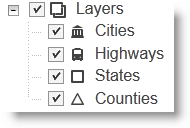
Whenever you click any of the checkboxes the associated map layer is, depending on the new checkbox state, either shown or hidden. To enable this functionality we need to add an event handler to the tree which will capture events of type checkBoxClick.
function layerClicked (item, treeNode, event ) {
  // A checkbox was clicked, get all layers from the store whose checked
  // state is 'true' and update layer visibility.
  var layers   = store.query( {"type":"layerInfo", defaultVisibility:true} );
  var layerIds = layers.map( function(layer) {
    return layer.id;
  });
  map.getLayer("usa").setVisibleLayers(layerIds.length ? layerIds : [-1]);
}

tree.on("checkBoxClick", layerClicked);
To change a layers visibility we must pass the setVisibleLayers() function
an array of all layer Ids that will be visible. Therefore, instead of
focusing on the specific checkbox that was clicked, we simply query the store
for all objects of type layerInfo with their current checked state
(defaultVisibility) set to true.
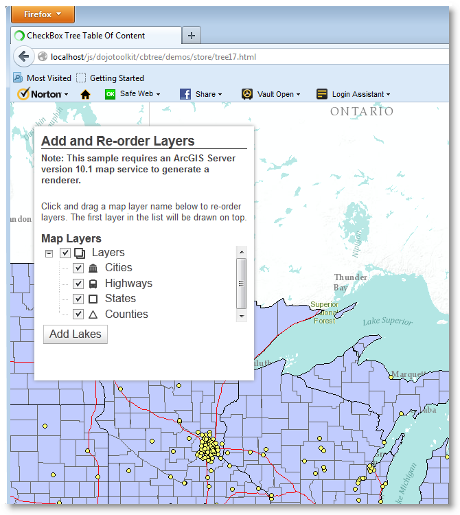
The layer order determines how the layers are stacked on the canvas. The layer first in the list is always drawn on top. You can change the layer order as follows: Click a layer and drag it to a new location in the TOC.
The CheckBox Tree configuration in this particular demo gives you two options:
- Drop the layer in between two other layers or,
- Drop the layer on top of another layer.
If you drop a layer on top of another layer it will become a child of the layer you dropped it on. Please note this does not mean it comes a sublayer in the context of the map. It merely allows you to group layers in a parent-child fashion.
To track Drag-n-Drop movement of layers within the TOC an event handler is established with the model which listens for pasteItem events:
function reorderLayers(item, insertIndex, before) {
  // Layer was dragged to a new location.

  function getLayers(parent, layers) {
    // Get all the children with type 'layerInfo' for the parent
    var children = store.getChildren(parent);
    var layers   = layers || [];

    children.forEach( function (child) {
      getLayers(child, layers);
    });
    if (parent.type == "layerInfo") {
      layers.push( parent );
    }
    return layers;
  }

  var layers = getLayers( store.get("layers") );
  if (layers.length) {
    map.getLayer("usa").setDynamicLayerInfos(layers);
  }
}

model.on("pasteItem", reorderLayers );
Whenever an item is pasted onto the TOC, (e.g. the mouse button is released after
the drag operation), the reorderLayers() function is called. At this point the
model has already told the store to re-insert the dragged item at the new location.
The reorderLayers() function collects all records with type layerInfo in the
order they appear in the store hierarchy starting from the top.
Although pretty efficient, the reorderLayers() function listed above could be
simplified if we would use the cbtree QueryEngine and the store extension
Ancestry. In order to do so we would need to load the two extra modules with
the others:
require([          ...
          "cbtree/util/QueryEngine",
          "cbtree/store/extensions/Ancestry"
        ], function ( ... , QueryEngine, Ancestry ) {
  // First, create a query function.
  var queryFunction = QueryEngine( {type:"layerInfo"} );
                  ...
  function reorderLayers(item, insertIndex, before) {
    // Get all descendants of "layers" whose type is "layerInfo".
    var layers = queryFunction( store.getDescendants("layers") );
    if (layers.length) {
      map.getLayer("usa").setDynamicLayerInfos(layers);
    }
  }
                  ...
});
In this implementation we simply create a query function
once that will return all records whose type property is set to layerInfo.
The Ancestry extension offers the ability to get all
descendants of any object in a
hierarchical store. Combining the two eliminates the need for the getLayers()
function in the original implementation.
To get all the desired records in the correct order we can simply write:
var records = queryFunction( store.getDescendants("layers") );You may wonder: What do we need to the queryFunction for? Aren't all descendants already layerInfo objects? The answer is yes. However, most of the times you will have a much more elaborate TOC with many different record types. Using the Query Engine makes it very easy to filter, paginate and sort objects.
Give it a try...
The CheckBox Tree and Tree Styling extension located at
cbtree/extensions/TreeStyling offer several ways to assign custom icons to
tree nodes. This particular demo uses the 'Value To Icon' method which allows
you to map property value(s) to specific icons.
To map a property value to an icon, or better yet a css classname, you need three things:
- An image sprite (collection of images).
- A css definition file for the images and,
- Mapping rules.
For this demo we use the css file maki.css located at cbtree/icons/maki.css
which in turn loads the image sprite cbtree/icons/images/maki.png. The image
sprite is a single image containing 6 icons, each 18x18 pixels, as shown below:

When creating the CheckBox Tree we set the valueToIconMap property, which is part of the TreeStyling extension, as follows:
valueToIconMap: { icon: {"*":"* maki"} }What the above mapping rule does is, it replaces the wildcard character (*)
with the value of the store item property icon, creating the css classname
for the tree node icon.
For example, if a store item has its icon property set to highways the
rule transforms in real-time to {icon: {"highways":"highways maki"}} mapping
the icon property value highways to the css classname 'highways maki'.
Given the above mapping rule, and knowing all posible values of the icon property, we can now define the css rule sets for the image sprite:
.maki {
	background-image: url('images/maki.png');
	background-repeat: no-repeat;
	width: 18px; height: 18px;
	margin: 0; padding: 0;
}
.maki.layers { background-position: -0px;}
.maki.cities { background-position: -18px;}
.maki.highways { background-position: -36px; }
.maki.states {background-position: -54px;}
.maki.counties {background-position: -72px;}
.maki.lakes {background-position: -90px;}The full code listed below can be found at cbtree/demos/store/tree17.html
<!doctype html>
<html>
  <head>
    <meta charset="utf-8">
    <meta http-equiv="X-UA-Compatible" content="IE=7,IE=9">
    <meta name="viewport" content="initial-scale=1, maximum-scale=1,user-scalable=no">
    <title>CheckBox Tree Table Of Content</title>

    <link rel="stylesheet" href="http://serverapi.arcgisonline.com/jsapi/arcgis/3.3/js/dojo/dijit/themes/tundra/tundra.css">
    <link rel="stylesheet" href="http://serverapi.arcgisonline.com/jsapi/arcgis/3.3/js/esri/css/esri.css">
    <link rel="stylesheet" href="../../themes/tundra/tundra.css">
    <link rel="stylesheet" href="../../icons/maki.css">

    <style>
      html, body { height: 100%; width: 100%; margin: 0; padding: 0; }
      h3 { margin: 0 0 5px 0; border-bottom: 1px solid #444; }
      .shadow {
        -moz-box-shadow: 0 0 5px #888;
        -webkit-box-shadow: 0 0 5px #888;
        box-shadow: 0 0 5px #888;
      }
      #map{ margin: 0; padding: 0; }
      #feedback {
        background: #fff;
        color: #444;
        font-family: arial;
        height: 310px;
        left: 30px;
        margin: 5px;
        padding: 10px;
        position: absolute;
        top: 30px;
        width: 310px;
        z-index: 40;
      }
      #note, #hint { font-size: 80%; }
      #note { font-weight: 700; padding: 0 0 10px 0; }
      #layerList {
        width: 300px;
      }
    </style>

    <script type="text/javascript">
      var dojoConfig = {
            parseOnLoad: true,
            packages: [
              { name: "cbtree",location: "/../../../" }
            ]
      };
    </script>

    <!-- Load the esri ArcGIS API 3.3 for JavaScript -->
    <script type="text/javascript" src="http://serverapi.arcgisonline.com/jsapi/arcgis/3.3/"></script>
    <script type="text/javascript">
      require(["dojo/aspect",                    // aspect.after()
               "dojo/ready",                    // ready()
               "dijit/tree/dndSource",
               "esri/dijit/Popup",
               "cbtree/Tree",
               "cbtree/extensions/TreeStyling",
               "cbtree/model/ForestStoreModel",
               "cbtree/store/ObjectStore",
               "dijit/layout/BorderContainer",
               "dijit/layout/ContentPane",
               "dijit/form/Button",
               "esri/map"
              ], function (aspect, ready, dndSource, Popup, Tree, TreeStyling,
                            ForestStoreModel, ObjectStore) {

      var map, store, model, tree;

      function on (target, event, listener) {
        // Mimic dojo/on for non-emitters like esri.layers
        var method = "on" + event.replace(/^[a-z]/, function(c) { return c.toUpperCase(); });
        aspect.after( target, method, listener, true );
      }

      function buildTOC (location) {
        var index = [  { id:"layers", tocName:"Layers", icon:"layers", type:"TOC" }  ];

        store = new ObjectStore({data: index});
        model = new ForestStoreModel( { store: store,
                                        labelAttr:"tocName",
                                        checkedAttr:"defaultVisibility",
                                        query:{"type":"TOC"}
                                      });
        // Create the checkbox tree adding DnD support and value to icon mapping.
        tree  = new Tree( { model: model,
                            dndController: dndSource,
                            betweenThreshold: 5,
                            valueToIconMap: { "icon": {"*":"* maki"} },
                            autoExpand: true,
                            showRoot:false
                           },
                           location);
        tree.startup();
      }

      function layerClicked (item, treeNode, event ) {
        // A checkbox was clicked, get all layers from the store whose checked
        // state is 'true' and update layer visibility.
        var layers   = store.query( {"type":"layerInfo", defaultVisibility:true} );
        var layerIds = layers.map( function(layer) {
          return layer.id;
        });
        map.getLayer("usa").setVisibleLayers(layerIds.length ? layerIds : [-1]);
      }

      function storeLayers(layerInfos) {
        // Layers have been loaded, hide the loading icon add any new layers
        // to the store.
        dojo.style(dojo.byId("loading"), "display", "none");
        if (!layerInfos.hasOwnProperty("dynamicLayerInfos")) {
          var dynLayerInfos = map.getLayer("usa").createDynamicLayerInfosFromLayerInfos();
        } else {
          var dynLayerInfos = layerInfos.dynamicLayerInfos
        }
        dynLayerInfos.forEach( function (layerInfo) {
          if (!store.get(layerInfo.id)) {
            layerInfo.tocName = layerInfo.name.split(".").pop();
            layerInfo.icon    = layerInfo.tocName.toLowerCase();
            layerInfo.type    = "layerInfo";

            store.put( layerInfo, { parent: "layers"} );
          }
        },this);
      }

      function reorderLayers(item, insertIndex, before) {
        // Layer was dragged to a new location.

        function getLayers(parent, layers) {
          // Get all the children with type 'layerInfo' for the parent
          var children = store.getChildren(parent);
          var layers   = layers || [];

          children.forEach( function (child) {
            getLayers(child, layers);
          });
          if (parent.type == "layerInfo") {
            layers.push( parent );
          }
          return layers;
        }

        var layers = getLayers( store.get("layers") );
        if (layers.length) {
          map.getLayer("usa").setDynamicLayerInfos(layers);
        }
      }

      function addLakes() {
        var dataSource, layerSource, drawingOptions, dynamicLayerInfo;
        var layerName = "ss6.gdb.Lakes";
        var options   = [];

        // show a loading icon and disable the "Add Lakes" button
        dojo.style(dojo.byId("loading"), "visibility", "visible");
        dijit.byId("lakes").set("disabled", true);

        // get existing layerInfos from the store.
        var dynLayerInfos = store.query( {type:"layerInfo"} );

        // create a table data source to access the lakes layer
        dataSource = new esri.layers.TableDataSource();
        dataSource.workspaceId = "MyDatabaseWorkspaceIDSSR2"; // not exposed via REST, sad face :(
        dataSource.dataSourceName = layerName;
        // and now a layer source
        layerSource = new esri.layers.LayerDataSource();
        layerSource.dataSource = dataSource;

        // create a new dynamic layer info object for the lakes layer
        dynamicLayerInfo        = new esri.layers.DynamicLayerInfo();
        dynamicLayerInfo.id     = dynLayerInfos.total;
        dynamicLayerInfo.name   = layerName;
        dynamicLayerInfo.source = layerSource;

        dynLayerInfos.push( dynamicLayerInfo );
        // set new infos, but don't refresh, map will be updated when the
        // drawing options are set
        map.getLayer("usa").setDynamicLayerInfos( dynLayerInfos, true);

        drawingOptions = new esri.layers.LayerDrawingOptions();
        drawingOptions.renderer = new esri.renderer.SimpleRenderer(
          new esri.symbol.SimpleFillSymbol(
            "solid",
            null,
            new dojo.Color([255, 0, 255, 0.75]) // fuschia lakes!
          )
        );
        options[4] = drawingOptions;

        map.getLayer("usa").setLayerDrawingOptions(options);
      }

      function init() {
        var urlBase = "http://services.arcgisonline.com/ArcGIS/rest/services/World_Terrain_Base/MapServer";
        var urlRef  = "http://services.arcgisonline.com/ArcGIS/rest/services/Reference/World_Reference_Overlay/MapServer";
        var urlDyn  = "http://sampleserver6.arcgisonline.com/arcgis/rest/services/USA/MapServer";
        var popup   = Popup(null, dojo.create("div"));

        map = new esri.Map("map", {
          center: [-86.636, 44.882],
          zoom: 6,
          infoWindow: popup,
          slider: false
        });

        var basemap  = new esri.layers.ArcGISTiledMapServiceLayer(urlBase);
        var refLayer = new esri.layers.ArcGISTiledMapServiceLayer(urlRef);
        var usaLayer = new esri.layers.ArcGISDynamicMapServiceLayer(urlDyn, { "id": "usa" });

        map.addLayers([basemap, refLayer, usaLayer]);

        // Create TOC store, model and tree.
        buildTOC("layerList");

        // build the layer list
        if ( usaLayer.loaded ) {
          storeLayers( map.getLayer("usa") );
        }
        // Establish event listeners.
        on (usaLayer, "updateEnd", function() {
          // Add any new layers to the TOC
          storeLayers( map.getLayer("usa") );
        });
        // add the lakes layer to the existing map service
        on (dijit.byId("lakes"), "click", addLakes);

        tree.on("checkBoxClick", layerClicked);
        model.on("pasteItem", reorderLayers );
      }
      // Let's get started when dojo is ready...
      ready (init);
    });
    </script>
  </head>

  <body class="tundra">
    <div data-dojo-type="dijit/layout/BorderContainer"
         data-dojo-props="design:'headline',gutters:false"
         style="width: 100%; height: 100%; margin: 0;">
      <div id="map"
           data-dojo-type="dijit/layout/ContentPane"
           data-dojo-props="region:'center'">

        <div id="feedback" class="shadow">
          <h3>Add and Re-order Layers</h3>
          <div id="info">
            <div id="note">
              Note:  This sample requires an ArcGIS Server version 10.1 map service to generate a renderer.
            </div>

            <p id="hint">
              Click and drag a map layer name below to re-order layers. The first layer in the list will be drawn on top.
            </p>

            <strong>Map Layers</strong>
            <img id="loading" src="http://dl.dropbox.com/u/2654618/loading_black.gif" />
            <br />
            <div id="layerList"></div>

            <button id="lakes" data-dojo-type="dijit.form.Button">Add Lakes</button>

          </div>
        </div>
      </div>
    </div>
  </body>
</html>