-
Notifications
You must be signed in to change notification settings - Fork 167
Working_with_Mars_Reconnaissance_Orbiter_(MRO)_Data
Working with Mars Reconnaissance Orbiter (MRO) Data 
MRO 
Brief Mission Summary 
NASA's Mars Reconnaissance Orbiter, launched in 2005, is searching for evidence that water persisted on the surface of Mars for a long period of time. While other Mars missions have shown that water flowed across the surface in Mars' history, it remains a mystery whether water was ever around long enough to provide a habitat for life.
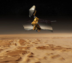
Mars Reconnaissance Orbiter Artist's concept. Credit: NASA/JPL
Science Goals 
Mars Reconnaissance Orbiter seeks to obtain science data that will provide researchers with information for locating safe landing sites for future missions and tell researchers about the history of water on Mars. The spacecraft instruments will zoom in for extreme close-up images of the Martian surface in order to analyze minerals, look for subsurface water, trace how much dust and water are distributed in the atmosphere, and monitor daily global weather.
These studies will help determine if there are deposits of minerals that form in water over long periods of time, detect any shorelines of ancient seas and lakes, and analyze deposits placed in layers over time by flowing water. It will also be able to tell if the underground ice discovered by the Mars Odyssey orbiter is the top layer of a deep ice deposit, or if it is a shallow layer in equilibrium with the current atmosphere and its seasonal cycle of water vapor.
The orbiter's primary mission ended about three Earth years after launch, in November 2008, and currently it is on its second extended mission. For details on all mission stages, see the Mission Timeline (NASA) .
Science Instruments 
During its two-year primary science mission, the Mars Reconnaissance Orbiter conducted eight different science investigations at Mars. The investigations are functionally divided into three purposes: global mapping, regional surveying, and high-resolution targeting of specific spots on the surface.
Mars Reconnaissance Orbiter Instruments Artist's concept showing spacecraft instruments monitoring water cycle on Mars. Credit: NASA/JPL
- HiRISE (High Resolution Imaging Science Experiment) This high-resolution, visible-range camera can reveal small objects in the debris blankets of mysterious gullies and details of geologic structure of canyons, craters, and layered deposits.
- CTX (Context Camera) This camera provides wide area views to help provide a context for high-resolution analysis of key spots on Mars provided by HiRISE and CRISM.
- MARCI (Mars Color Imager) This weather camera monitors clouds and dust storms.
- CRISM (Compact Reconnaissance Imaging Spectrometer for Mars) This spectrometer covers the range of visible and near-infrared light, useful for identifying minerals, especially those likely formed in the presence of water.
- MCS (Mars Climate Sounder) This atmospheric profiler detects vertical variations of temperature, dust, and water vapor concentrations in the Martian atmosphere.
- SHARAD (Shallow Radar) This sounding radar probes beneath the Martian surface to see if water ice is present at depths greater than one meter.
References & Related Resources 
Mars Reconnaissance Orbiter (MRO) Mission and Instrument 
- Mission Overview: http://mars.jpl.nasa.gov/mro/
High Resolution Imaging Science Experiment (HiRISE) 
- Instrument Overview: http://mars.jpl.nasa.gov/mro/mission/instruments/hirise/
- Instrument Team: http://hirise.lpl.arizona.edu/
- Online data volumes: http://pds-imaging.jpl.nasa.gov/volumes/mro.html
Context Imager (CTX) 
- Instrument Overview: http://mars.jpl.nasa.gov/mro/mission/instruments/ctx/
- Instrument Team: http://www.msss.com/all_projects/mro-ctx.php
- Online data volumes: http://pds-imaging.jpl.nasa.gov/volumes/mro.html
Mars Color Imager (MARCI) 
- Instrument Overview: http://mars.jpl.nasa.gov/mro/mission/instruments/marci/
- Instrument Team: http://www.msss.com/all_projects/mro-marci.php
- Online data volumes: http://pds-imaging.jpl.nasa.gov/volumes/mro.html
Planetary Data System (PDS) Information and Data Search Tools 
- PDS Geosciences Node, Lead Node for MRO:
http://geo.pds.nasa.gov/missions/mro/default.htm
- Mars Orbital Data Explorer: http://ode.rsl.wustl.edu/mars/
- PDS Imaging Node:
- Data Release Calendar: http://pds-imaging.jpl.nasa.gov/schedules/mro_release.html
- MRO Mission: http://pds-imaging.jpl.nasa.gov/portal/mro_mission.html
- Photojournal: http://photojournal.jpl.nasa.gov/mission/MRO
- Planetary Image Atlas: http://pds-imaging.jpl.nasa.gov/search/search.html#QuickSearch
- Planetary Image Locator Tool (PILOT): http://pilot.wr.usgs.gov/index.php?view=map&target=mars
- PDS Engineering Node:
- Global data search engine: http://pds.nasa.gov/
- PDS Atmospheres:
- Accelerometer Data: http://pds-atmospheres.nmsu.edu/data_and_services/atmospheres_data/Mars/Mars.html
- Climate Sounder Data: http://pds-atmospheres.nmsu.edu/data_and_services/atmospheres_data/Mars/Mars.html
- PDS Navigation and Ancillary Information Node:
- Building
- Writing Tests
- Test Data
- Start Contributing
- Public Release Process
- Continuous Integration
- Updating Application Documentation
- Deprecating Functionality
- LTS Release Process and Support
- RFC1 - Documentation Delivery
- RFC2 - ISIS3 Release Policy
- RFC3 - SPICE Modularization
- RFC3 - Impact on Application Users
- RFC4 - Migration of ISIS Data to GitHub - Updated Information 2020-03-16
- RFC5 - Remove old LRO LOLA/GRAIL SPK files
- RFC6 - BLOB Redesign
- Introduction to ISIS
- Locating and Ingesting Image Data
- ISIS Cube Format
- Understanding Bit Types
- Core Base and Multiplier
- Special Pixels
- FAQ

