The ArcGIS Developer Bundle is the perfect combination of innovation and digital sovereignty.
It provides you with advanced, innovative tools for development of customized solutions using ArcGIS Enterprise, while also allowing you to maintain control over your digital sovereignity. Experience the perfect blend of technology and control with the ArcGIS Developer Bundle.
As digital transformation accelerates, technology cycles are becoming increasingly shorter. We understand that you, as a developer, need straightforward access to ArcGIS Enterprise for development and testing within secure sandbox environments.
List all the included software products.
from devbundle.content import DevBundle

bundle = DevBundle()
bundle.software_names
['ArcGIS Enterprise', 'ArcGIS Notebook Server', 'ArcGIS Knowledge', 'ArcGIS GeoEvent Server', 'ArcGIS GeoAnalytics Server', 'ArcGIS Image Server']
Show the detailed description of the Buffer analysis tool.
from devbundle.arcpy.analysis import Buffer

buffer_tool = Buffer()
print(buffer_tool.description)
Buffer_analysis(in_features, out_feature_class, buffer_distance_or_field, {line_side}, {line_end_type}, {dissolve_option}, {dissolve_field;dissolve_field...}, {method})
Creates buffer polygons around input features to a specified distance.
INPUTS:
in_features (Feature Layer):
The input point, line, or polygon features that will be buffered.
buffer_distance_or_field (Linear Unit / Field):
The distance around the input features that will be buffered.
Distances can be provided as either a value representing a linear
distance or a field from the input features that contains the distance
to buffer each feature.If linear units are not specified or are
entered as Unknown, the
linear unit of the input features' spatial reference will be used.When
specifying a distance, if the linear unit has two words, such as
Decimal Degrees, combine the two words into one (for example, 20
DecimalDegrees).
line_side {String}:
Specifies the sides of the input features that will be buffered. This
parameter is only supported for polygon and line features.FULL-For
lines, buffers will be generated on both sides of the line.
For polygons, buffers will be generated around the polygon and will
contain and overlap the area of the input features. This is the
default.LEFT-For lines, buffers will be generated on the topological
left of
the line. This option is not supported for polygon input
features.RIGHT-For lines, buffers will be generated on the topological
right of
the line. This option is not supported for polygon input
features.OUTSIDE_ONLY-For polygons, buffers will be generated outside
the input
polygon only (the area inside the input polygon will be erased from
the output buffer). This option is not supported for line input
features.This optional parameter is not available with a Desktop Basic
or
Desktop Standard license.
line_end_type {String}:
Specifies the shape of the buffer at the end of line input features.
This parameter is not valid for polygon input features.ROUND-The ends
of the buffer will be round, in the shape of a half
circle. This is the default.FLAT-The ends of the buffer will be flat
or squared and will end at
the endpoint of the input line feature.This optional parameter is not
available with a Desktop Basic or
Desktop Standard license.
dissolve_option {String}:
Specifies the type of dissolve that will be performed to remove buffer
overlap.NONE-An individual buffer for each feature will be maintained,
regardless of overlap. This is the default.ALL-All buffers will be
dissolved together into a single feature,
removing any overlap.LIST-Any buffers sharing attribute values in the
listed fields
(carried over from the input features) will be dissolved.
dissolve_field {Field}:
The list of fields from the input features on which the output buffers
will be dissolved. Any buffers sharing attribute values in the listed
fields (carried over from the input features) will be dissolved.
method {String}:
Specifies whether the planar or geodesic method will be used to create
the buffers. PLANAR-If the input features are in a projected
coordinate
system, Euclidean buffers will be created. If the input features are
in a geographic coordinate system and the buffer distance is in linear
units (meters, feet, and so forth, as opposed to angular units such as
degrees), geodesic buffers will be created. This is the default.
You can use the Output Coordinate System environment setting to
specify the coordinate system to use. For example, if the input
features are in a projected coordinate system, you can set the
environment to a geographic coordinate system to create geodesic
buffers.GEODESIC-All buffers will be created using a shape-preserving
geodesic
buffer method, regardless of the input coordinate system.
OUTPUTS:
out_feature_class (Feature Class):
The feature class containing the output buffers.
Deliver industry-leading mapping and analytics to your infrastructure and the cloud.
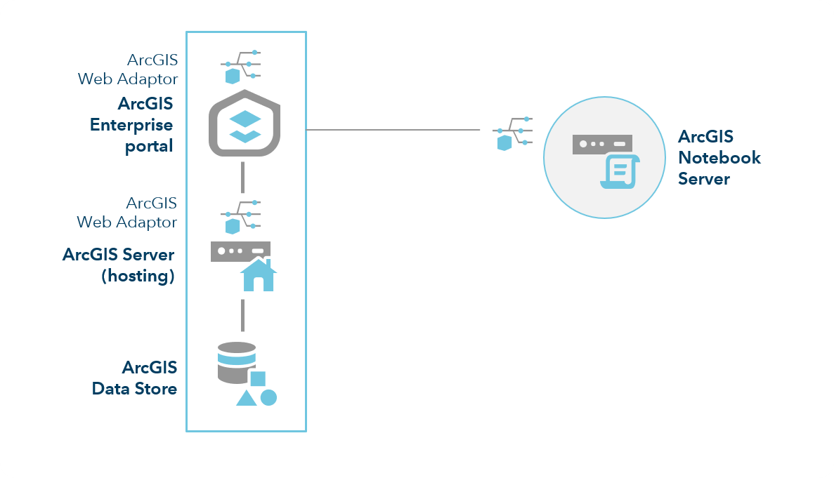
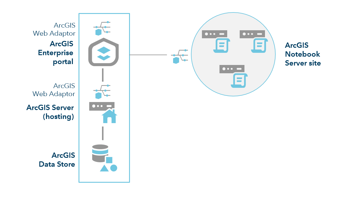
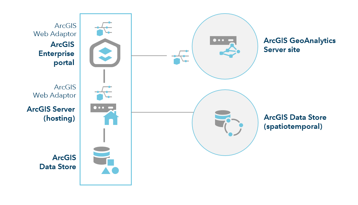
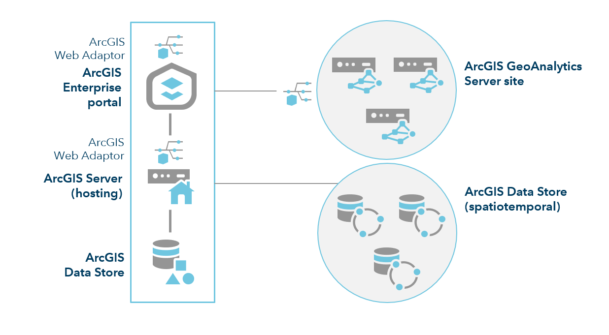
The power of data science in your enterprise GIS.
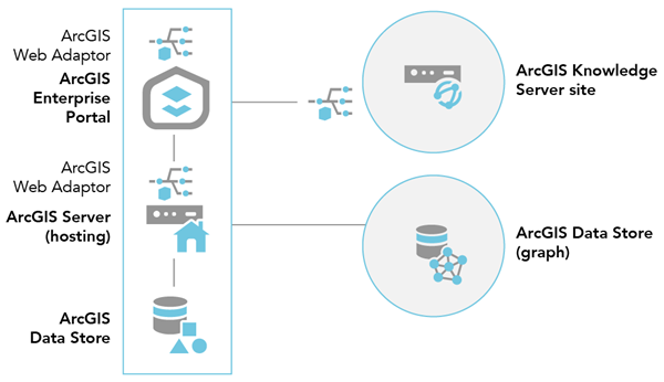
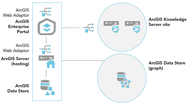
Where knowledge graphs and link analysis meet GIS.
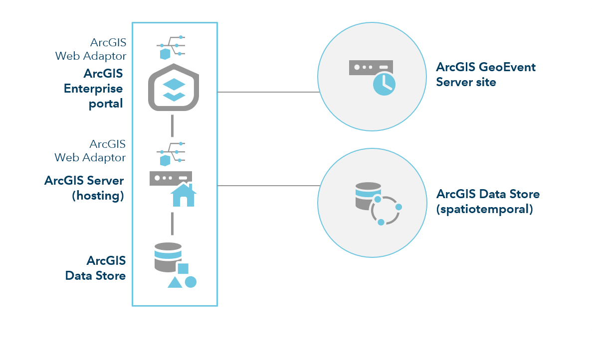
Real-time visualization and analytics in your frontline GIS apps.
Bring advanced big data analytics to your organization.
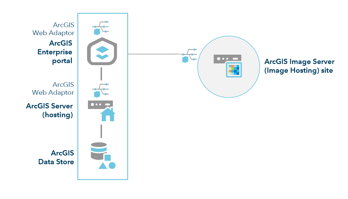
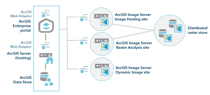
Share large volumes of imagery and power raster analytics.